Minfra approves new polygonal area to double the Port of Santos’ area
Jan, 20, 2022 Posted by Gabriel MalheirosWeek 202203
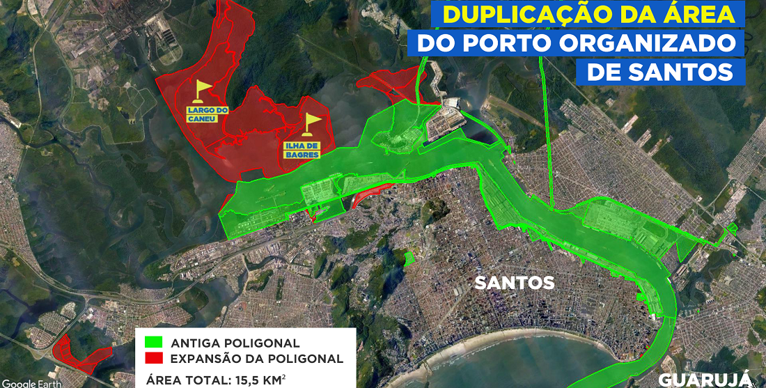
Ordinance nº 66, issued on Wednesday, January 19th by the Ministry of Infrastructure, redefines the jurisdictional area of the Organized Port of Santos, also known as the port’s polygon area. The new polygon, which includes the port’s administrative perimeter, facilities, and leased terminals, increases the dry area managed by the Santos Port Authority (SPA) from 8 km² to 15,5 km².
The expansion includes greenfield areas for the development of new projects and adds value to the SPA privatization, which is scheduled for the second half of the year.
The expansion enlarges the port’s continental reach towards the navigation channel, with the Ilha de Brages and Largo do Caneu regions accounting for nearly 6km² of the new 8km².
“The polygon area is very advantageous for SPA’s future private concessionaire. If privatization were to be limited to current contracts, the asset’s value would suffer as a result of a lower growth outlook. Now we’ve corrected that by adding a new growth factor that will be very important in the next 40 years,” says Fernando Biral, president of the Santos Port Authority (SPA).
The privatization model, whose documents are expected to be released in the coming weeks, will already include the “doubling” of the port area, a significant and decisive step to increase the asset’s value in the auction process.
Biral also claims that the new polygonal area will allow for a wide range of investments in projects such as port-industry ventures and new terminals, which would provide the region with enormous economic growth potential. The issuing of the new Development and Zoning Plan (PDZ) will contemplate the occupation of the various areas.
In addition to the dry area, the Port of Santos polygon also includes maritime anchorage areas, the navigation channel and its maneuvering basins in the estuary, as well as the Itatinga Hydroelectric Power Plant. The SPA-managed polygon spreads over five municipalities: Santos, Guarujá, Cubatão, Bertioga, and Biritiba-Mirim (the Serra do Mar environmental preservation area, attached to the Itatinga Power Plant).
-
Ports and Terminals
Sep, 05, 2024
0
BTP innovates by completing the first 5G private network project in the port sector in Latin America
-
Shipping
Nov, 11, 2024
0
ZIM accelerates rollout of smart containers with hoopoSense solar trackers
-
Economy
Oct, 15, 2024
0
Significant Growth in Argentina-Brazil Trade in September
-
Shipping
Feb, 15, 2022
0
Robert Mærsk Uggla to lead Maersk as the new company chair

