


Bioceanic bridge links Brazil and Paraguay, but access roads delay completion
Jul, 28, 2026 Posted by Gabriel MalheirosWeek 202631
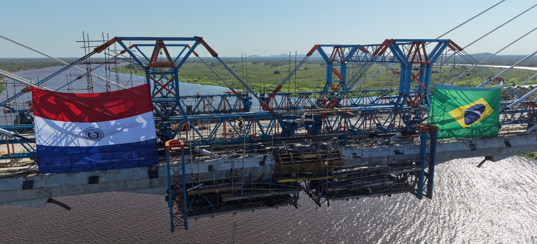
Cloudy weather forced officials to cancel the formal ceremony marking the connection of the two sides of the new bridge between Porto Murtinho, in Brazil’s Mato Grosso do Sul state, and Carmelo Peralta, Paraguay, on Thursday, July 23.
Even so, with temperatures near 10°C (50°F), representatives from both countries gathered at the exact point where the two sections of the 1,294-meter bridge met above the Paraguay River.
The informal celebration marked a symbolic milestone for the Bioceanic Corridor, a trade route designed to shorten Brazilian exports’ journey to Asian markets through Pacific ports by as much as 17 days.
On the ground, however, the two ends of the Integration International Bridge reveal a clear disparity in construction progress.
On the Brazilian side, a 13.1-kilometer road linking the bridge to federal highway BR-267 has yet to be completed. The project requires around R$250 million in additional funding, which is not currently included in the federal budget.
On the Paraguayan side, work is under way on a 3.8-kilometer paved connection to highway PY-15.
Brazil’s government expects its access road to be completed in 2027, while Paraguayan authorities estimate that their section will be ready by November 2026.
Beyond the road links, the two governments still need to finalize details of a joint customs-control system, which Paraguay accepted after 18 months of negotiations. Sections of road in Argentina and Chile, the other two countries along the corridor, must also be upgraded or paved.
Atlantic-to-Pacific trade route
The Bioceanic Corridor is a Brazilian federal government initiative intended to connect the Atlantic Ocean, beginning at the Port of Santos, with the Pacific through the Chilean ports of Antofagasta and Iquique.
The route crosses Brazil, Paraguay, Argentina and Chile, with the new bridge over the Paraguay River serving as one of its most important infrastructure projects. Until the bridge and its access roads are ready, vehicles will continue crossing this stretch of the Pantanal wetlands by ferry.
The corridor is expected to make the movement of Brazilian goods to markets in Asia and Oceania faster and more efficient.
Cargo exported through Santos currently follows much longer maritime routes, either sailing around Africa or passing through the Panama Canal, increasing transit times and logistics costs.
The new overland connection is expected to shorten the journey by around 7,000 kilometers and reduce shipping times between Brazil and Asia by an estimated 17 to 20 days.
Brazilian access road remains less than halfway complete
Work on the Brazilian side is currently focused on earthmoving and supporting infrastructure. According to Brazil’s National Department of Transport Infrastructure, or DNIT, 10.1 kilometers of earthmoving have been completed.
DNIT said 38.1% of the overall project has been executed.
The works also include seven major engineering structures—six bridges and one overpass. Only two have been completed, while the others remain at different stages of construction.
Of the projected R$472 million investment, DNIT said R$220.7 million has been committed and R$184.7 million has been spent.
The remaining R$36 million in funds already committed will be used to complete the bridges and overpass. Regarding the balance needed for the project, DNIT said additional budget resources could be allocated as work progresses.
On the Paraguayan side, an estimated 45% to 50% of the planned work has been completed, according to Brazilian diplomat João Carlos Parkinson, who coordinates the government’s international negotiations on bioceanic corridors and has been one of the main proponents of the route.
The PYBRA Binational Consortium is responsible for building the bridge and the Paraguayan access road.
Civil engineer René Gomez, the consortium’s chief construction coordinator and works superintendent, estimated that 30% of the 3.8-kilometer road had been completed. He expects it to be finished by the end of 2026 or, at the latest, January 2027.
Parkinson acknowledged that there was “a slight mismatch” between progress on the two sides but said the projects faced different conditions.
“The access road on the Paraguayan side is much shorter, while the terrain on the Brazilian side is extremely marshy and will require extensive earthmoving, which makes the project more expensive,” he said.
According to Parkinson, the remaining R$251.3 million could come from Brazil’s Treasury through Itaipu Binacional or from a loan issued by the Inter-American Development Bank.
Joint border-control facilities still pending
Part of the funding will also be used for an Integrated Border Control Center, known by its Portuguese acronym CIOF, where agencies from both countries will conduct joint inspections under an arrangement concluded in 2026.
Erivelto Moyses, deputy superintendent of Brazil’s Federal Revenue Service in its 1st Region, said that once the access roads are completed, authorities must prioritize construction of the Integrated Control Area.
The facility will form part of the broader border-control complex but will have a more specialized role.
“It is the essential area for foreign trade and for processing imports and exports,” Moyses said.
Parkinson said Brazil’s Federal Revenue Service already has personnel available to operate customs facilities in Porto Murtinho, along with teams from the Federal Police and Federal Highway Police.
The main difficulty is expected to be filling the positions required by the Ministry of Agriculture and Livestock and Brazil’s health surveillance agency, Anvisa.
According to DNIT, work on the customs center has not yet begun because the design is being revised to accommodate additional requirements submitted by border-control agencies.
Assessment finds infrastructure bottlenecks along the route
Between May 30 and June 8, a Federal Revenue Service team traveled approximately 4,000 kilometers along the Bioceanic Corridor through Brazil, Paraguay, Argentina and Chile to assess infrastructure, logistics and inspection conditions.
Moyses said the mission confirmed the corridor’s potential to reduce transport costs and transit times but also identified several bottlenecks that must be addressed before the route can operate at full capacity.
In Paraguay, the paved highways were found to be in good condition. Customs and immigration facilities in Carmelo Peralta and Pozo Hondo, however, were described as inadequate and operating from temporary structures.
Some sections of the route remain unpaved, while construction continues on the link to Argentina.
In Argentina, the team found limitations across the road network, including bridges with weight restrictions, sections without shoulders and insufficient border infrastructure.
Chile’s highways and the ports of Iquique and Antofagasta received positive assessments because of their operating capacity and expansion plans.
Crossing the Andes, however, imposes restrictions on trucks and will require logistics adjustments and additional preparation for drivers.
Source: Folha de São Paulo
-
Meat
Apr, 23, 2019
0
African swine fever in China likely to cut soy exports and lift meat sales
-
Grains
Feb, 27, 2023
0
Soy: MY 2022/23 sales total 3.733 million t in Argentina
-
Ports and Terminals
Apr, 01, 2025
0
Port of Santos Explores PPP Model to Focus on Operations
-
Other Logistics
Oct, 22, 2020
0
Santos Brasil inaugurates new distribution center in São Paulo state